|
Tahoe Nugget #16:
Lone Pine Earthquake
Next week I'm heading out for my annual sojourn along the eastern escarpment of the Sierra Nevada range. It's a time to absorb the peace and
quiet of open spaces and explore some of the most dynamic climate and geologic features in the United States. At this time of year the crowds are gone and the scenery is always spectacular. This year I am not going
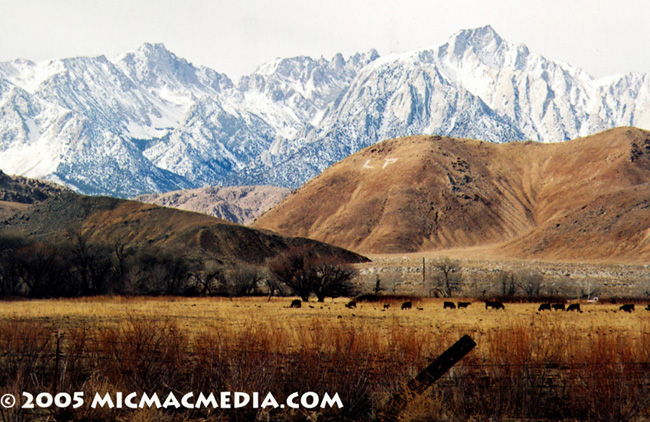
east into Nevada (not enough time), but will drive south down Highway 395, a route packed with history, including the 1872 Lone Pine earthquake. (Note in the photo the letters LP on the mountainside. The white
washed rocks placed by local high school students spell out the initials of this small community for all to see (a common practice in the West).
On March 26, 1872, a powerful earthquake, estimated at 8.3 on the Richter Scale, terrorized the 300 residents of Lone Pine, about 350 miles south of
Reno. The heaving ground broke plaster from ceilings and tossed water pitchers six feet into the air. Citizens grabbed what clothes they could and ran from their collapsing homes. Timber is very scarce in this
region so all dwellings were adobe construction. Out of the 62 buildings lining Main Street, 52 crashed to the ground in piles of rubble. Falling bricks and debris killed 27 people. The first tremor cracked and
threw down many walls and buildings, but it was the succeeding aftershocks that leveled the town. At Big Pine, 43 miles to the north, the tectonic violence injured many and tore the land apart. A large fissure
opened from 50 to 200 feet wide and 20 feet deep. The dramatic Lone Pine earthquake offers a glimpse into the powerful geologic forces that are still building the Sierra Nevada. Vertical displacement was measured at
nearly 17 feet! It left no doubt in the minds of California and Nevada residents that their shared mountain range could still grow in leaps and bounds.

|


