 |
|
|
Follow Mark on Facebook for more stories |
||
 |
|||||
|
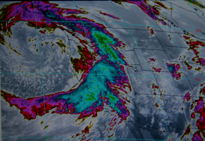
Tahoe Nugget #129: Historic Storm or Media Hype? The sensationalized "Storm of Historic Proportions" is over and now that the dust has settled, it's time to ask the question: "Was the media hysteria and national coverage dedicated to this storm appropriate?" As usual when it comes to analyzing powerful weather events, it depends on whom you ask. Snowfall totals along Lake Tahoe's north shore were nothing special, averaging about four feet, but there are a few characteristics about what the Weather Channel kept calling "a monster storm" that are worth noting. The barometric pressure of the most intense part of the three storm series was about 29.37 inches, the lowest in modern times for California. Similar to hurricanes, the deeper the low the more powerful the storm, and this baby was no exception. Wind speeds were impressive. Maximum sustained winds in the Bay Area reached 53 mph (about 20 mph less than the sustained winds of a minimum hurricane), but low altitude wind gusts near San Francisco peaked at nearly 90 mph. High winds ravaged the southern Sacramento Valley, including the city of Sacramento, with gusts to 70 mph. The extensive wind damage in the lower elevations put more than 1.5 million people in the dark up and down California. Near Lake Tahoe, the maximum wind gust peaked at a whopping 165 mph on Ward Mountain at 8,637 feet in elevation. Surprisingly, very few people lost power in the Tahoe Truckee region during the storm, a fact that I credit to diligent utility crews and amazing luck. As of today, three days after the wind event ended in the flat lands, there are still nearly 100,000 people without electricity due to downed trees and power lines. Rainfall totals in the lower elevations were not that exceptional for such a powerful winter storm, but the combination of high wind and intense downpours combined to cause minor flooding in various locations. Randall Osterhuber, lead scientist at the Central Sierra Snow Laboratory near 7,000-foot Donner Pass measured only 50 inches of fresh snow. It rained at the lab for a few hours during the storm, indicative of the subtropical moisture being pumped into the region. Total snowfall accumulations in the higher elevations at Tahoe ski resorts ranged from 5 feet to more than 11 feet, an impressive boost to the snowpack. Although two skiers were injured at Squaw Valley USA in a small avalanche, there were remarkably few incidents of lost skiers and no fatalities. I skied at Homewood Mountain Resort today, on Lake Tahoe's west shore. Conditions were good with lots of wind packed powder and some fine loose stuff in the trees. The new base of five feet plus has really opened up the terrain, and I'm sure the deeper snow on the bigger mountains has the powder hounds yelping there too! Even more important than the big hit of powder for skiers and boarders was the bulking up of the snowpack and its critical water content. Before the storm, the Sierra snowpack stood at a miserly 40-50% of normal, and it appeared that a second consecutive dry winter was looming. But after the storm, the snowpack's water content shot up to 95% to 124% of normal for the date, a tremendous improvement in just three days! Photo #1: Infrared satellite image of the "monster storm" hitting California on Jan. 4, 2008.
|
|||||
|


