 |
|
|
Follow Mark on Facebook for more stories |
||
 |
|||||
|
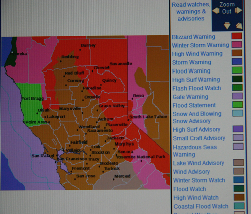
Tahoe Nugget #128: Blizzard Warning: The Big One! The National Weather Service has posted rare Blizzard Warnings for the Sierra Nevada and the Lake Tahoe/Truckee region. An extremely powerful winter storm is slamming into the mountains today, with heavy snow and very high winds expected. The jet stream is packing winds in excess of 200 mph, so wind gusts on the mountains ridges will exceed 150 mph. Gusts to 100 mph are anticipated in the Reno area and along the Eastern Sierra Front. As far as I know, the greatest wind gust on record for the Tahoe area is 183 mph measured at Squaw Valley. Precipitation rates with this storm are expected to be exceptional, with snowfall rates of 6 to 8 inches per hour during the frontal passage later today. Snowfall accumulations in the Tahoe Basin should range from 2 to 3 feet, with up to 10 feet of new snow at the ski resorts by Monday morning. The current low-pressure system is the second (and most powerful) of a 3-storm series expected to last through the weekend. This winter storm has been well advertised by the National Weather Service and media. Warnings of potential blizzard conditions and life threatening road conditions were posted days in advance. Previous weather systems this winter have been disappointing considering their forecasted snow production, but everyone is taking this series of storms very seriously. Sometimes I wonder about the "irrational exuberance" that occasionally accompanies the NWS winter forecast discussions, but the extreme wind speeds (exceeding 150 mph on mountain ridges and 70 mph through the highway passes) and heavy snowfall expected with this system warrants the dangerous storm headlines. The combination of the tightly-wrapped low-pressure system and a powerful 200 mph jet stream ripping across the region is dangerous and potentially deadly. Another important factor in the hyped-up weather warning is the number of tourists and visitors still enjoying their holidays in Truckee and the Tahoe Basin. Blinding whiteout conditions are expected due to the high winds and heavy snowfall. The potential for extended road closures on the major trans-Sierra highways is a very real possibility and I've told as many people as possible that this might not be the best series of storms to ride out like a hurricane party. Especially since I expect the power to go out for at least some time during this storm event. There was a lot of excited hyperbole among NWS forecasters and the media about how the spate of storms could generate snowfall of "historic proportions." But whenever an exceptional storm pattern pounds the region, many wonder if it was the most powerful in a century, a decade, or just the biggest snowfall since a lot of new folks have moved to the region? As is often the case with major weather events, the correct answer depends on your perception and location. You don't have to be longtime Tahoe local to remember that it was just three years ago that the region was inundated with a series of powerful storms that were widely declared to be the worst on record. Snowfall numbers were very impressive in the Sierra, but not quite record setting. Between December 28, 2004, and January 11, 2005, National Weather Service cooperative observer Don Huber recorded 98 inches of snow near the Truckee Ranger Station. During the same time span, observers in Tahoe City reported 118 inches of snowfall. Compare that to the 130 inches measured in Tahoe City in Jan. 1911 during a four-day storm, or the 108 inches recorded during another four-day event in Jan. 1952. Randall Osterhuber, lead scientist at the Central Sierra Snow Laboratory (CSSL) near Donner Pass, tallied 155 inches of snowfall during the 2005 barrage. That's 12.9 feet of snow in 15 days, but there have been other storm periods that dumped more at the CSSL. Close to 14 feet was measured at the lab after an 11-day storm in January 1969, and that was exceeded in 1982 by a 15.5-foot snowfall over 13 days. In February 1999, Sugar Bowl Ski Resort (near Donner Pass) was blessed with an impressive 14 feet of powder in a potent three-day storm. After the storm event in January 2005, local resorts reported anywhere from 12 to 19 feet of fresh snow. Squaw Valley totaled 12.5 feet new accumulation at the 8,200-foot level during the storm period, while other resorts claimed much more. We'll just have to wait and see how much snow the "Blizzard of 2008" delivers. Photo #1: The NWS website is lit up like a Christmas tree. The bold red Blizzard Warning is a rare sight.
|
|||||
|


